|
2003 Expeditions
The 2003 ALAS expeditions were carried out at the El Ceibo station and the Cascante Refuge in Braulio Carrillo National Park.
Dates and participants: Three members of the ALAS staff (Danilo Brenes, Maylin Paniagua, Ronald Vargas) were present during all expeditions. The fourth ALAS staff member, Flor Cascante, was based in the ALAS lab in La Selva, where she received and processed samples and maintained communications with the field camp. The following expedition dates list visiting collaborators.
11-24 February: John Longino and son August and student Lisa Schonberg, Marc Pollet and wife Anja De Braekeleer, Scott Brooks and wife Carol Chenard, Anna Himler and Rachelle Adams (students of Ulrich Mueller), Steve Gaimari and student Martin Hauser, Dave Wagner, student Kenji Nishida, Jens Prena, Jerry Powell and student Amanda Heddle, Jenny Phillips, student Akito Kawahara.
11-24 March: Dmitri Maslov, David Furth and student Kira Zhaurova, Marc Epstein, Larry Kirkendall and students David Rees and Karoliina Koivisto, Jens Prena, Angel Solis, Michael Sharkey and student Kevin Pitz, Robert Anderson and student Pat Bouchard, John Brown and assistant Addie Brown and student Sarah Garrett, Carlos Viquez, student Michelle DaCosta, student Jadranka Rota, student Michael Canfield, Pettar Jordan.
8-21 April: Jens Prena, Neville Winchester and assistant Kevin Jordan, Valerie Behan-Pelletier, student Tom Goldschmidt, Evert Lindquist (at La Selva), Ed Riley, Shawn Clark, Gita Bodner, G. B. Edwards, Wills Flowers, Don Davis and wife Mignon Davis, student Kenji Nishida, Carlos Viquez, Gunnar Brehm.
Group Photos:
Feb 11-17 2003
Feb 17-24 2003
Mar 11-17 2003
Apr 8-14 2003
Photos from February expedition, 11-17 Feb 2003: Click here.
Photos that Larry Kirkendall took of 11-17 Mar 2003 expedition: click here.
Kira Zhaurova's images from the 11-17 Mar 2003 expedition: click here.
Locality Data
Printed labels for the two localities are as follows.
Immediate vicinity of El Ceibo station, on west side of Rio Peje:
Costa Rica, Prov. Heredia:
10km SE La Virgen, 450-
550m, 10deg20'N 84deg05'W
____________________2003
INBio-OET-ALAS transect
"Cascante" refuge area on transect trail, east side of Rio Peje:
Costa Rica, Prov. Heredia:
11km SE La Virgen, 450-
550m, 10deg20'N 84deg04'W
____________________2003
INBio-OET-ALAS transect
Site Description
An aerial photo was taken in 1988. The general terrain is one of moderately sloping land cut by many steep ravines. Much of the moderately level land was cleared for farms before the land was purchased for the park, and primary forest is often restricted to the steep ravine margins. Although the landscape is a mosaic of regenerating second growth vegetation and primary forest, with fairly extensive regions of primary forest, the main trail is restricted to second growth because it originally connected the string of small farms along the ridges. However, no spot is very distant from mature forest, and if one is prepared to bushwhack through second growth, follow stream channels, or clamber down very steep slopes old growth forest can be found. In places the second growth forest has become quite large after 15-20 years of regrowth. The second growth areas have mostly become tall closed-canopy forest, but there are remnant patches of thick grass in some areas.
|
|
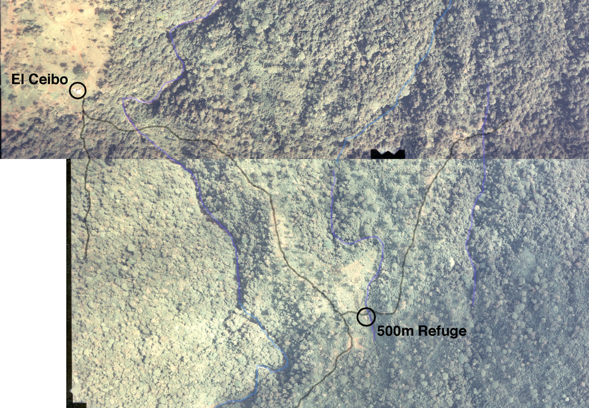
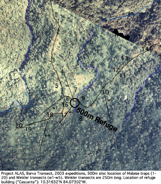
The guard station called El Ceibo (Figure 3, 4, 5, 6) sits on the west side of the Rio Peje, at the edge of extensive pasture land. Those who went on the expeditions to the 1070m site in 2001 will recognize it as the end of the road where the trail begins. From there the trail drops steeply down to the Rio Peje, where a cable car crosses the river. The trail climbs steeply up the east side of the ravine, then follows the east margin of the ravine upslope. After a short distance it comes to the main transect trail on the left, and a short distance down that trail is a small shelter called Cascante (Figure 8, 9). The shelter has one main room with wood floor (Figure 10) and a roofed in shed (Figure 11). The outhouse is in need of repair, which will mean eviction of its primary tenant . There is a small stream immediately behind the shelter (Figure 14). The shelter is down in a stream valley, and quite enclosed in secondgrowth vegetation .
The trail continues past the shelter building. It crosses the stream, climbs to a small ridge, then follows the ridge downslope for a kilometer or so before dropping down to another stream. This stream is delightful, in a deep channel but relatively level and meandering, such that one can easily walk upstream from where the trail crosses. Beyond the stream there is old growth forest.
There is a patch of dense forest south (upslope) of the El Ceibo station (west side of Rio Peje), with a trail that extends at least a kilometer.
Unloaded it takes about 30-40 minutes to walk from El Ceibo to the 500m refuge building.
|


)
)
)
)
)
)
)
)
)
)
)
)
)
)
)
)
)
)
)